

Guruh Gemurai Waterfall
Kuntan Singingi District is not only famous for its cultural attractions such as the Pacu Jalur ( Craft Racing ) but also its natural attractions. Such nature waterfall, now which are priorities is the improvement of local government Kuansing District is Guruh Gemurai Waterfalls. Kuansing local government has indeed reorganize this attraction with the availability of a paved road so is easy to reach, the parking area, an open stage to organize events, such as music concerts and other mosque also has been available in Guruh Gemurai Waterfall
 .
.
Guruh Gemurai Waterfall is located in Kuantan Mudik District (Lubuk Jambi), exactly in Kasang Village. You can reach it by personal vehicles and public transport. The distance from Taluk Kuantan the capital city of Kuansing District about 25 kilometers towards Kiliran Jao (border of West Sumatra-Riau). You will pass Lubuk Jambi Traditional Market, and then find two paths forked, choose the left side of the uphill road, this area is called Koto Village (KoteAte), through slightly curved road, five minutes away you'll get to the Kasang Village, and persevere your trip in ten minutes, then it would not be long you will met with a gate in right side of the highway that said Welcome to Guruh Gemurai Falls attractions. Until now a tourist attraction admission rates are in accordance with the decree has been set by the Internal Revenue Service Regency Kuantan Singingi, at Rp. 1000 for for two-wheeled vehicles, Rp. 1,500 for four-wheeled vehicles, Rp. 3000 for adults and Rp. 1000 for the children.
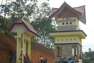


Guruh Gemurai was name taken from language of the local area. Guruh means rumbling from the sound of waterfalls. While Gemurai is the sound of splashing water are scattered. Then the Guruh Gemurai was means the waterfalls which rumbling and splashing.
On weekends and holidays, Attractions: Waterfalls Guruh Gemurai crowded and become a mainstay of Attraction Kab.Kuansing mainstay.
READ MORE
 |
| Pacu Jalur |


Guruh Gemurai was name taken from language of the local area. Guruh means rumbling from the sound of waterfalls. While Gemurai is the sound of splashing water are scattered. Then the Guruh Gemurai was means the waterfalls which rumbling and splashing.
On weekends and holidays, Attractions: Waterfalls Guruh Gemurai crowded and become a mainstay of Attraction Kab.Kuansing mainstay.
BIntan Island
Bintan Island is the largest island in the Riau Islands cluster, about 50 miles south of Singapore. The main economic activities bintan island, besides mining and trade between islands is tourism. The natural beauty, a shiny white sand, blue water, and thick trees, is a mix that makes the Bintan Island is so beautiful.
The presence of Bintan island as one of Indonesia's tourism icons emerging in 1991. In collaboration with the Singapore government, the Indonesian government built a special tourism area with international standard. In 1996, Bintan Resorts officially opened. Manager of Bintan Resorts transform an area of 23 thousand hectares of becoming a haven for tourists. Various potential tourist attractions in the area is managed very well.


The manager built at least seven different resorts with many facilities. Angsana Resort for example, there are golf facilities, water sports, like jacuzi and spa. While at Banyan Tree Bintan, available villas natural shades. There is also some sort of exclusive facilities like jacuzi and a swimming pool .. All of these really makes pampered tourists.
Another with Mayang Sari Beach Resort, with its views directly to the beach. Once out of the chalet (a kind of bungalow) at Mayang Sari, you will immediately feel the softness of white sand beach that lies. All of the resorts in Bintan Resort have private beaches. For those of you who like underwater adventure, these area also provides diving and snorkeling. Additionally, tourists can also enjoy the fun of playing banana boating, parasailing, and windsurfing.
Bintan Resorts provides fishing facilities, including cooperation with the local traditional fishermen. With this cooperation, those who like fishing can learn ways to catch fish in traditional ways. For those of you who like explore the natural, also provided facilities for explore through your hobby or tracking mountain bikes to the Mountain Star. Located at an altitude of about 340 m, your eyes will be free to view the beauty of Bintan Island, which is annually visited by no less than 350 thousand tourists. Indeed, most of the tourists which come are not domestic, but foreign tourists, such as Singapore, South Korea, and Japan.
Tourism on the Bintan Island, especially in the northern part of the island known as Lagoi. Lagoi area very nicely arranged with maximum security to ensure safety for tourists. Lagoi arrangement is similar to the arrangement of Nusa Dua Bali, with some 5 star hotel, golf course and spa. To simplify foreign tourists, especially those from Singapore, deals in luxury hotels using the Singapore dollar or Us dollars. Although Bintan Island has no airport, but access, both from Batam and Singapore is very good.
If Lagoi reserved to foreign tourists, the beach of Trikora located in the eastern Bintan Island is intended for domestic tourists. There are two versions of the origin of the name of Trikora. The first is connected with the words "three Corals" which supposedly spoken by the first foreign settlers on the island decades ago. Another version connects the name with Tri Komando Rakyat. A "national euphoria" which is echoed by the late Sukarno, Indonesia's first president, in connection with a campaign of confrontation with Malaysia a few decades ago.


Not only natural beauty, Bintan Island also has a wealth of biodiversity to be proud of. As an island in the tropics, Bintan Island has a unique ecosystem with variety of flora and fauna. Monkeys, frogs, various types of snakes, fireflies, lizards, and various species of birds live in comfort on the island. Yet, exploring in the mangrove forest in which once Sebung River had broken. Along the River Sebung we will find various types of mangrove forest quite unique as Pencil Avioennia Roots, Roots DanceInternasional.Stilt Rhizophora, Bruguiera Knee Roots, and Roots Xylocarpus Ribbon.


READ MORE
The presence of Bintan island as one of Indonesia's tourism icons emerging in 1991. In collaboration with the Singapore government, the Indonesian government built a special tourism area with international standard. In 1996, Bintan Resorts officially opened. Manager of Bintan Resorts transform an area of 23 thousand hectares of becoming a haven for tourists. Various potential tourist attractions in the area is managed very well.

The manager built at least seven different resorts with many facilities. Angsana Resort for example, there are golf facilities, water sports, like jacuzi and spa. While at Banyan Tree Bintan, available villas natural shades. There is also some sort of exclusive facilities like jacuzi and a swimming pool .. All of these really makes pampered tourists.
Another with Mayang Sari Beach Resort, with its views directly to the beach. Once out of the chalet (a kind of bungalow) at Mayang Sari, you will immediately feel the softness of white sand beach that lies. All of the resorts in Bintan Resort have private beaches. For those of you who like underwater adventure, these area also provides diving and snorkeling. Additionally, tourists can also enjoy the fun of playing banana boating, parasailing, and windsurfing.
Bintan Resorts provides fishing facilities, including cooperation with the local traditional fishermen. With this cooperation, those who like fishing can learn ways to catch fish in traditional ways. For those of you who like explore the natural, also provided facilities for explore through your hobby or tracking mountain bikes to the Mountain Star. Located at an altitude of about 340 m, your eyes will be free to view the beauty of Bintan Island, which is annually visited by no less than 350 thousand tourists. Indeed, most of the tourists which come are not domestic, but foreign tourists, such as Singapore, South Korea, and Japan.
Tourism on the Bintan Island, especially in the northern part of the island known as Lagoi. Lagoi area very nicely arranged with maximum security to ensure safety for tourists. Lagoi arrangement is similar to the arrangement of Nusa Dua Bali, with some 5 star hotel, golf course and spa. To simplify foreign tourists, especially those from Singapore, deals in luxury hotels using the Singapore dollar or Us dollars. Although Bintan Island has no airport, but access, both from Batam and Singapore is very good.
If Lagoi reserved to foreign tourists, the beach of Trikora located in the eastern Bintan Island is intended for domestic tourists. There are two versions of the origin of the name of Trikora. The first is connected with the words "three Corals" which supposedly spoken by the first foreign settlers on the island decades ago. Another version connects the name with Tri Komando Rakyat. A "national euphoria" which is echoed by the late Sukarno, Indonesia's first president, in connection with a campaign of confrontation with Malaysia a few decades ago.


Not only natural beauty, Bintan Island also has a wealth of biodiversity to be proud of. As an island in the tropics, Bintan Island has a unique ecosystem with variety of flora and fauna. Monkeys, frogs, various types of snakes, fireflies, lizards, and various species of birds live in comfort on the island. Yet, exploring in the mangrove forest in which once Sebung River had broken. Along the River Sebung we will find various types of mangrove forest quite unique as Pencil Avioennia Roots, Roots DanceInternasional.Stilt Rhizophora, Bruguiera Knee Roots, and Roots Xylocarpus Ribbon.

Fortr Marlborough
After about 140 years in Bengkulu, the British government has left many historical legacy which one of them is Fort of Marlborough. Strong building was built in 1713 until 1719 during the leadership of Governor Joseph Collet.
In 1712 Joseph Collet was appointed Deputy Governor, he built a new fortress on a rock facing the sea. Construction of the fort of Marlborough then lasted for 4 years (1714-1718). Joseph Collet named with Fort of Marlborough taken from the name of a British nobleman and hero, namely John Churchill, Duke of of Marlborough I. The fortress is the largest in Asia is was once the center of British colonial rule which controls the province of Bengkulu since 1685-1825.

With the 17th century architecture, the fort of Marlborough really have an attraction that is rarely found in other places. Additionally, the location is being in one area with attractions Tapak Padri Beach presents a mix of natural attractions and history. Besides, the lodgings for tourists are also already available within a radius of 1 km from the fort. It is not surprising if this object is a leading tourist attraction for the city of Bengkulu.


Since the first built, the fort of Marlborough has held a strategic function in the field of ideological, political, economic, social, cultural, defense and security so that is interesting commodity research. John Bastin in his book "The British in West Sumatra" (1685-1825) provides many information about the events surrounding the fort of Marlborough. Based on one of the recorded information, the fort of Marlborough been left by the British government for nearly five years, in 1719-1724. To be interesting to know more about who controls the the fort of Marlborough and what happened during those 5 years.
In the reign of Thomas Stamford Raffles in 1818-1824, Bengkulu became famous. Then in 1825, England bartering with the Dutch, which controlled the territory of Malaysia and Singapore. The next Dutch occupied the fort of Marlborough until World War II. During World War II, Japanese troops occupied the whole of Sumatra until the Japanese surrendered in 1945. After independence, the fort was used by the military and national police until 1970.
READ MORE
In 1712 Joseph Collet was appointed Deputy Governor, he built a new fortress on a rock facing the sea. Construction of the fort of Marlborough then lasted for 4 years (1714-1718). Joseph Collet named with Fort of Marlborough taken from the name of a British nobleman and hero, namely John Churchill, Duke of of Marlborough I. The fortress is the largest in Asia is was once the center of British colonial rule which controls the province of Bengkulu since 1685-1825.

With the 17th century architecture, the fort of Marlborough really have an attraction that is rarely found in other places. Additionally, the location is being in one area with attractions Tapak Padri Beach presents a mix of natural attractions and history. Besides, the lodgings for tourists are also already available within a radius of 1 km from the fort. It is not surprising if this object is a leading tourist attraction for the city of Bengkulu.

Since the first built, the fort of Marlborough has held a strategic function in the field of ideological, political, economic, social, cultural, defense and security so that is interesting commodity research. John Bastin in his book "The British in West Sumatra" (1685-1825) provides many information about the events surrounding the fort of Marlborough. Based on one of the recorded information, the fort of Marlborough been left by the British government for nearly five years, in 1719-1724. To be interesting to know more about who controls the the fort of Marlborough and what happened during those 5 years.
In the reign of Thomas Stamford Raffles in 1818-1824, Bengkulu became famous. Then in 1825, England bartering with the Dutch, which controlled the territory of Malaysia and Singapore. The next Dutch occupied the fort of Marlborough until World War II. During World War II, Japanese troops occupied the whole of Sumatra until the Japanese surrendered in 1945. After independence, the fort was used by the military and national police until 1970.
Putung Attractions in Karangasem
Putung Attractions located in the Eastern Duda Village, Selat District, Karangasem regency. Putung attractions had a range of about 64 km from Denpasar, ± 19 km from Amlapura City - the capital of the district - and easily reached by public transport, as well as private vehicles. Developed as a tourist attraction because of its nature in the mountains surrounded by snake fruit plantation.

The main tourist attraction is the beauty of nature Putung which is a blend of panoramic hills, valleys, seas, forests, and plantations snake fruit with refreshing cool air. From the height, we can see rice plots owned by residents of Adat Buitan Village, District Manggis and Labuhan Amuk with the vast stretches of blue sea with jukung (boats) of fishermen which was sailing, cruise ship (cruise) who happened to come rests, and distant Nusa Penida island, Klungkung regency seems obvious. Putung tourist attraction locatied nearby Agrotourism Sibetan snake fruit objects in District Bebandem.
Putung became famous for its panoramic beauty of nature because the painting Mr. Christiano, an Italian painter who lived some time in Putung and marry a woman from the village of Manggis Karangasem.


READ MORE
The main tourist attraction is the beauty of nature Putung which is a blend of panoramic hills, valleys, seas, forests, and plantations snake fruit with refreshing cool air. From the height, we can see rice plots owned by residents of Adat Buitan Village, District Manggis and Labuhan Amuk with the vast stretches of blue sea with jukung (boats) of fishermen which was sailing, cruise ship (cruise) who happened to come rests, and distant Nusa Penida island, Klungkung regency seems obvious. Putung tourist attraction locatied nearby Agrotourism Sibetan snake fruit objects in District Bebandem.
Putung became famous for its panoramic beauty of nature because the painting Mr. Christiano, an Italian painter who lived some time in Putung and marry a woman from the village of Manggis Karangasem.

National Monument (Monas)
National Monument, known as Monas or Tugu Monas is located in the Monas Field, Central Jakarta, was built in 1960. The National Monument is one of the memorial is erected to commemorate the resistance and the Indonesian people's struggle against the Dutch colonialists.
Form of memorial that one is very unique, is the cornerstone obeliks marble yoni phallus-shaped fertility symbol based on Hindu culture. This monument towering as high as 132 meters (other versions say 137 meters height is calculated with the existing space under the ground 5 meters).

At the top are National Monument that sustains the cup-shaped bronze torches weighing up to 14.5 tons and 35 kg of gold coated. Torch or flame burning is a symbol of the spirit of struggle of the people of Indonesia who was never extinguished in achieving independence. It was said at the time of Indonesia celebrates 50 years of independence in 1995 a number of Indonesian businessmen donate some gold so that the total weight of gold that coats the flame of freedom on top of the Monas be 50 kg. The National Memorial was built in an area of 80 hectares. The architect who designed this monument is Soedarsono and Frederich Silaban, a consultant Ir. Rooseno, began construction in August 1959, and was inaugurated August 17, 1961 by President Sukarno. Monas was officially opened to the public on July 12, 1975.

The court peak with an area of 11 m x 11 m can accommodate as many 50 visitors. At around the body are evelator emergency stairs made of iron. From the top of the monument Monas courtyard, visitors can enjoy views all over the city. Directions into south stands firmly in the distance Mount Salak in Bogor regency, West Java, stretching north sea with small islands scattered about. While into West extends the Soekarno-Hatta Airport that every time it appeared the plane took off.


Monas area visitors, who want to ride the top court of the Monas monument or museum, could through the entrance on the plaza surrounding the park Merdeka Square, in the north of Monas Park. Nearby are fountain and statue of Prince Diponegoro who was riding a horse made of bronze, weighing 8 tons.
The statue was created by Italian sculptor, Prof.. Coberlato as a donation by the Consulate General of Honores, Dr. Mario in Indonesia. Through the tunnel that is 3 feet below the park and cross the road this Monas, the entrance of visitors to the top of Monas monument fenced "Yellow Bamboo". Basic foundation of Monas as high as 3 meters, at the bottom there is the living history museum of the national struggle with the size 80 x 80 meters wide, can accommodate around 500 visitors.
The statue was created by Italian sculptor, Prof.. Coberlato as a donation by the Consulate General of Honores, Dr. Mario in Indonesia. Through the tunnel that is 3 feet below the park and cross the road this Monas, the entrance of visitors to the top of Monas monument fenced "Yellow Bamboo". Basic foundation of Monas as high as 3 meters, at the bottom there is the living history museum of the national struggle with the size 80 x 80 meters wide, can accommodate around 500 visitors.
At the four sides of each room there are 12 window displays or dioramas dedicated life events since the time of the ancestors of Indonesia. Entire walls, pillars and marble floors for a total of 48 dioramas. In addition, the room of independence shaped amphitheater located in the cup Monas monument, depicting the attribute map of the Unitary Republic of Indonesia archipelago, Independence of RI, red and white flag and state emblem and the gate door that written the script Proclamation Independence of RI.
Mount Semeru
Mount Semeru or Sumeru is the highest volcano in Java, with its peakMahameru, 3676 meters above sea level. The crater at the summit of Mount Semeru known Jonggring Saloko.
Semeru has Hill dipterocarp forest, dipterocarp forest Upper Montane Forest,and Forest Ericaceous or mountain forests.

The mountain is located between the administration Lumajang and Malang Regency, with its geographical position between 8 ° 06 'latitude and 120 ° 55' East Longitude.
In 1913 and 1946 Crater Jonggring Saloka have dome with a height of 3744.8M until the end of November 1973. In the south, the dome is broke edge of thecrater caused lava flow leads to the south side of the covering area and Candipuro Pronojiwo in Lumajang.
It takes about four days to climb the peak of Mount Semeru round trip. To climb the mountain semeru can be reached by the city of Malang or Lumajang. From the terminal Malang we ride public transportation to the village Tumpang.Connected again with a jeep or Vegetables Truck in the back of the terminal market Tumpang.
READ MORE
Semeru has Hill dipterocarp forest, dipterocarp forest Upper Montane Forest,and Forest Ericaceous or mountain forests.
 |
In 1913 and 1946 Crater Jonggring Saloka have dome with a height of 3744.8M until the end of November 1973. In the south, the dome is broke edge of thecrater caused lava flow leads to the south side of the covering area and Candipuro Pronojiwo in Lumajang.
It takes about four days to climb the peak of Mount Semeru round trip. To climb the mountain semeru can be reached by the city of Malang or Lumajang. From the terminal Malang we ride public transportation to the village Tumpang.Connected again with a jeep or Vegetables Truck in the back of the terminal market Tumpang.
Gedung Sate
Gedung Sate, with its trademark form of ornament skewers on the central tower, has long been a bookmark or landmark of Bandung which not only known to the public in West Java, but also throughout Indonesia even model of building was used as a sign of some buildings and signs of the city in West Java. For example the front of the building form Railway Station Tasikmalaya. Gedung Sate was built in 1920, this white building is still standing strong but graceful and now serves as the central building of government of West Java.

Gedung Sate which in the Dutch East Indies was called Gouvernements Bedrijven (GB), laying the first stone by Johanna Catherina Coops, eldest daughter of the Mayor of Bandung, B. Coops and Petronella Roelofsen, representing the Governor-General in Batavia, JP Graaf van Limburg Stirum on July 27, 1920. The result of planning a team consisting of Ir.J.Gerber, a young architect leading Netherlands Delft graduates of the Faculty of Engineering, Ir. Eh. De Roo and Ir. G. Hendriks and van Gemeente Bandoeng party, headed by Col.. Pur. VL. Slors involving 2000 workers, 150 people including sculptors, or expert bongpay tombstone carver and wood engraver Chinese nationals from Konghu or Cantonese, assisted by masons, coolies stir and servers that come from residents in Kampung Sekeloa, Dago small hole Kampung, Kampung Gandok and Kampung Cibarengkok, which they had previously worked Gedong shingles (ITB Campus) and Gedong Papak (Bandung City Hall).

During the period of four years in September 1924, successfully completed the construction of the main building Gouverments Bedrijven stem, including the headquarters of the PTT (Postal, Telephone and Telegraph) and the Library.
Architecture Gedung Sate is a the work of architect Ir. J. Gerber and his group which not independent of the input maestro Dr.Hendrik Dutch architect Petrus Berlage, which his face the traditional architecture of Nusantara.
Many among architects and building experts expressed Gedung Sate is a stunning elegant monumental building with unique architectural style leads to a form of architectural style of Indo-European (Indo Europeeschen architectuur Stijl), so it is not impossible if the elegance of Borobudur participate coloring Gedung Sate.
READ MORE

Gedung Sate which in the Dutch East Indies was called Gouvernements Bedrijven (GB), laying the first stone by Johanna Catherina Coops, eldest daughter of the Mayor of Bandung, B. Coops and Petronella Roelofsen, representing the Governor-General in Batavia, JP Graaf van Limburg Stirum on July 27, 1920. The result of planning a team consisting of Ir.J.Gerber, a young architect leading Netherlands Delft graduates of the Faculty of Engineering, Ir. Eh. De Roo and Ir. G. Hendriks and van Gemeente Bandoeng party, headed by Col.. Pur. VL. Slors involving 2000 workers, 150 people including sculptors, or expert bongpay tombstone carver and wood engraver Chinese nationals from Konghu or Cantonese, assisted by masons, coolies stir and servers that come from residents in Kampung Sekeloa, Dago small hole Kampung, Kampung Gandok and Kampung Cibarengkok, which they had previously worked Gedong shingles (ITB Campus) and Gedong Papak (Bandung City Hall).

During the period of four years in September 1924, successfully completed the construction of the main building Gouverments Bedrijven stem, including the headquarters of the PTT (Postal, Telephone and Telegraph) and the Library.
Architecture Gedung Sate is a the work of architect Ir. J. Gerber and his group which not independent of the input maestro Dr.Hendrik Dutch architect Petrus Berlage, which his face the traditional architecture of Nusantara.
Many among architects and building experts expressed Gedung Sate is a stunning elegant monumental building with unique architectural style leads to a form of architectural style of Indo-European (Indo Europeeschen architectuur Stijl), so it is not impossible if the elegance of Borobudur participate coloring Gedung Sate.
Popular Post
-
 Bintan Island is the largest island in the Riau Islands cluster , about 50 miles south of Singapore . The main economic activi...
 -
 National Monument, known as Monas or Tugu Monas is located in the Monas Field, Central Jakarta, was built in 1960. The National Monument is...
 -
 Malibo Anai is a tourist spot facilities are complete enough , there is a swimming baths , inn and golf courses . Malibo Anai ...
 -
 Kawah Putih (White Crater) , this place located in the Ciwidey , Bandung in West Java . The scenery is quite beautiful and cool . On ...
 -
 Mount Semeru or Sumeru is the highest volcano in Java, with its peakMahameru, 3676 meters above sea level. The crater at the summit of Mount...